Pacific Coast Highway
San Francisco to San Diego on Highway 1, with the Pacific always on your right.
- Distance
- About 640 mi
- ≈ 1,030 km, rounded
- Time
- 5–7 days
- at a comfortable pace
- Best season
- Apr–Jun · Sep–Oct
- Start → finish
- San Francisco → San Diego
California’s Highway 1 is the American coastal drive: cypress-studded headlands in Monterey, the cliffs and bridges of Big Sur, elephant seals, Hearst Castle, the Spanish missions of Santa Barbara, Malibu’s surf and, finally, the palm-lined beaches of Southern California.
Day by day
- 1
Day 1 · San Francisco to Monterey
Leave the city on Highway 1 past Pacifica, the lighthouse at Pigeon Point and Santa Cruz’s boardwalk. Evening on Cannery Row; the Monterey Bay Aquarium tomorrow morning.
120 mi · 2 h 30Sleep: Monterey
- 2
Day 2 · Monterey, 17-Mile Drive, Carmel
The aquarium at opening, the private 17-Mile Drive (toll) past the Lone Cypress, then Carmel’s fairy-tale cottages and Point Lobos.
30 miSleep: Carmel
- 3
Day 3 · Big Sur
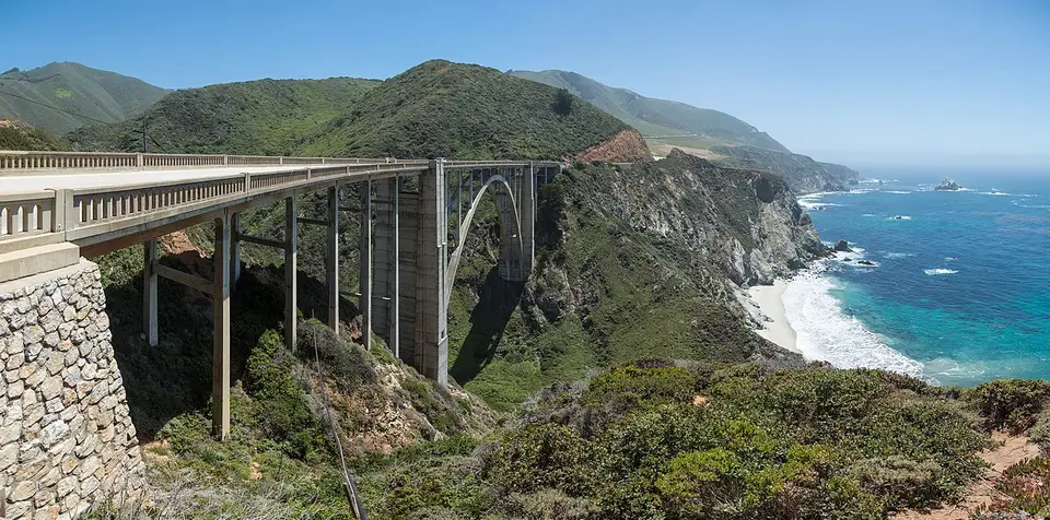
Bixby Bridge, Pfeiffer Beach, McWay Falls, lunch with a view. Slow down: there are no shortcuts. See our Big Sur guide.
95 mi · 3 h+Sleep: Cambria
- 4
Day 4 · Elephant seals & Hearst Castle
The elephant seal colony at Piedras Blancas, Hearst Castle’s opulent tours, Morro Bay’s rock, then San Luis Obispo’s college-town evening.
45 miSleep: San Luis Obispo
- 5
Day 5 · Santa Barbara
The “American Riviera”: the Old Mission, red-tiled State Street, Stearns Wharf, and wine tasting in the Funk Zone.
95 mi · 1 h 45Sleep: Santa Barbara
- 6
Day 6 · Malibu to Santa Monica
El Matador beach, Malibu’s surf, Point Dume, then the Santa Monica Pier and Venice. See our Los Angeles guide.
95 mi · 2 hSleep: Santa Monica
- 7
Day 7 · To San Diego
Laguna Beach’s coves, Dana Point, the Torrey Pines cliffs and La Jolla’s sea lions.
130 mi · 2 h 30+Sleep: [San Diego](/cities/san-diego/)
Short on days? Part of this route also works as a short trip, planned hour by hour:
Road closures and timing
Landslides regularly cut Highway 1 in Big Sur, sometimes for months. When the road is closed, drive Highway 101 inland between Monterey and San Luis Obispo and visit Big Sur as two out-and-back drives, from the north and from the south. Check Caltrans QuickMap the day before.
Highway 1 is slow: allow at least 50% more time than your GPS says, and don’t drive Big Sur after dark.
Where to sleep along the way
Book the nights that matter first — inside or next to the parks, and in towns hosting a festival — then fill in the rest. Free cancellation keeps the plan flexible.
- MontereyHotels ↗
- CarmelHotels ↗
- Big SurHotels ↗
- CambriaHotels ↗
- Santa BarbaraHotels ↗
- Santa MonicaHotels ↗
Partner links · Trip.com
Our hand-picked hotels on this route
Road trip questions
How many days do you need for the Pacific Coast Highway?
Five days from San Francisco to Los Angeles, seven to continue to San Diego with time at each stop.
Is it better to drive the PCH north to south?
Yes: the ocean is on your side, so pull-outs and views are easier and safer.
Is Highway 1 in Big Sur open?
It depends on landslides. Check Caltrans QuickMap before you go; a closure means detouring inland on Highway 101.
What is the best time to drive the PCH?
April to June and September to October. July and August often bring morning fog to the coast.
Written by Kylian Dev. Distances and drive times are without stops or traffic; add 25% for a realistic day.